Cartography constitutes an indissociable help for air prospections. On ground or in the plane, time always comes where one must identify a numerical point or an image, on a map: it is the localization.
Locate yourself in flight, with precision, is not easy after an hour of prospection, whereas you turned and zigzaged without stop, in search of possible sites. Then suddenly, some undeniable traces appear! You turn around, photograph them, and then comes the fateful moment of the announcement of co-ordinates at the tape recorder!
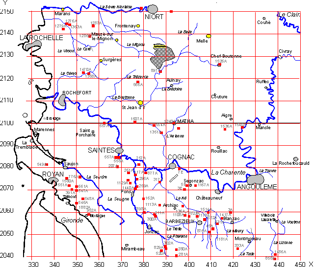
The GPS, associated with a pocket calculator and the suitable program, informs about the name of the map concerned and the famous Lambert co-ordinates! It only remains taking the good map in the collection aboard and to visually defer X on horizontal scale and Y on vertical scale defining this way on the map a square of 1 kilometer, where it becomes very easy to identify the zone corresponding to the traces. This implies the detention of a certain number of maps, relating to the covered zone. These maps are of two types:
The flight collection: maps IGN to the 1/50 000e. Our flight luggage includes about sixty maps covering a zone of a hundred km of range. Sites discovered there are represented by red points, quite visible.
The reference collection, held at the office, includes a hundred maps IGN, to the 1/25 000e. It's on this collection that will be traced in red the most representative form of discovered sites, like that of the traces photographed but not yet recognized like archaeological.
Interesting address , the French National Geographic Institute: http://www.ign.fr/
Cartography also makes possible to represent results of air archaeological prospections in a very synthetic form particularly appropriated particularly for articles and great general reports. We give a cartographic example of realization hereafter. The bottom used can be of two origins: a scanning of the IGN map(authorization of publication must be asked) or numerical cartographic bottom, sold by the IGN.
The drawing is done in a more readable cartographic background in the case of our applications. It is the case of the following example:
A cartographic repercussion: metric of ways.
Air prospections are an effective means to follow or find the layout of ancient ways, Gallo-Roman in particular. These ways were generally limited by milestones (milliary columns) which expressed distances between cities and/or limits of cities, since the point considered. The units used were, according to the area of Gaules, the miles or league.
The mile, (one thousand of double step from approximately 1,48 meter) = 1481 meters.
Value of the mile is perfectly defined by ancient texts: a Latin author, Ammianus Marcellus, gave equivalence between mile and league (leugae) in a famous passage where he wrote :" from place where Roman soldiers had started to be on the move until the barbarian cutting off, one counted 14 leugae, i.e. 21000 steps ". The mile was worth thus 1 thousand and half, i.e. 2222 meters. It is the value allowed by great reference works and taught in our universities.
If this value appears suitable in Narbonnaise, for example, there is other areas where, whatever the method of analysis adopted (old route, epigraphy, milliary, cartographic topography), one finds some module of distance of an appreciably more high value - 2400 to 2500 meter -.
We call this , from indigenous origin, the "Gallic league" opposite to the 2222 m one or "romanized league". It is the case in Poitou-Charentes where the search of metric of ways is one of the convergent elements for identifying Gallo-Roman places. With these methods we could identify Barzan CM with Novioregum the Antonin itinerary, on basis of a metric of approximately 2415 meters. One can suppose that the romanized league results from an " adaptation " of an indigenous unit in order to make it compatible with Roman units. Two leagues for three miles, a round ratio!
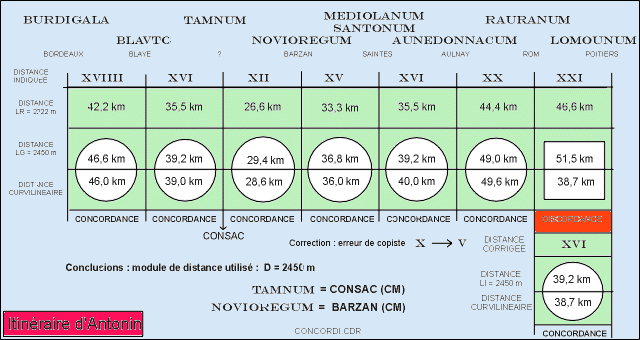
Agreements and discordances of the Antonin itinerary for leugae values of 2222 meters and 2450 meters.
Correction of an indication of the Rom-Poitiers segment is required by an error of a copyist who confused X with a V whose branches crossed a little high. This kind of error is frequent in the manuscripts.
|
|
|
|